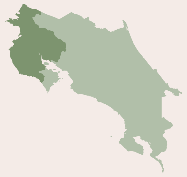
Guanacaste Province
The province of Guanacaste (see map) shares a border with the Alajuela and Puntarenas provinces, and with Nicaragua to the north. Within the Guanacaste province you will find Lake Arenal, however, its easternmost section, the part nearest to La Fortuna and Arenal Volcano, is part of the Alajuela province.
The capital of Guanacaste is Liberia, and the province is divided into 11 regions (cantons). Click on the text links below for accommodations in each region.
The first seven regions listed are those that reside primarily along the Pacific coast, starting with La Cruz and ending with Nandayure. We have listed them in order from north to south.
Coastal Regions: La Cruz - Liberia - Carrillo - Santa Cruz - Nicoya - Hojancha - Nandayure.
The remaining four sections, which are futher inland, are listed in alphabetical order
Interior Regions: Abangares - Bagaces - Cañas - Tilarán.
La Cruz
La Cruz
Google Map - La Cruz
Puerto / Playa Soley
Google Map - Puerto/Playa Soley
Playa Papaturro
Google Map - Playas Papaturro
Playa Pochotes
Google Map - Playa Pochotes
Playa El Jobo
Google Map - Playa El Jobo (Jobo Bay)
Sonzapote
Google Map - Sonzapote
Liberia
Liberia
Google Map - Liberia
Rincón de la Vieja
Google Map - Rincón de la Vieja
Carrillo
Golfo Papagayo - includes Playa Panamá
Google Map - Golfo Papagayo
Google Map - Playa Panamá
Playa Hermosa
Google Map - Playa Hermosa
Playas del Coco
Google Map - Playas del Coco
Playa Ocotal
Google Map - Playa Ocotal
Playa Matapalo
Google Map - Playa Matapalo
Playa Matapalcito
Santa Cruz
Playa Danta / Las Catalinas
Google Map - Playa Danta
Playa Pan de Azucar (Sugar Beach)
Google Map - Playa Pan de Azucar (Sugar Beach)
Playa Prieta
Google Map - Playa Prieta
Playa Penca / Potrero
Google Map - Playa Potrero
Playa Flamingo
Google Map - Playa Flamingo
Playa Brasilito
Google Map - Playa Brasilito
Playa Conchal
Google Map - Playa Conchal
Playa Grande
Google Map - Playa Grande
Playa Tamarindo
Google Map - Playa Tamarindo
Playa Langosta
Google Map - Playa Langosta
Playa Mancita / Hacienda Pinilla
Google Map - Playa Mancita
Playa Avellanas
Google Map - Playa Avellanas
Playa Largartillo
Google Map - Playa Largartillo
Playa Negra / Paraiso
Google Map - Playa Negra
Playa Junquillal
Google Map - Playa Junquillal
Marbella
Google Map - Marbella
Playa Azul
Google Map - Playa Azul
Playa San Juanillo
Google Map - Playa San Juanillo
Playa Ostional
Google Map - Playa Ostional
Nicoya
Playa Nosara & Playa Pelada
Google Map - Playa Nosara
Google Map - Playa Pelada
Playa Guiones
Google Map - Playa Guiones
Playa Garza
Google Map - Playa Garza
Playa Buenavista
Google Map - Playa Buenavista
Playa Sámara
Google Map - Playa Sámara
Hojancha
Playa Carrillo
Google Map - Playa Carrillo
Nandayure
Playa Punta Islita
Google Map - Playa Punta Islita
Playa Corozalito
Google Map - Playa Corozalito
La Javilla - just off the beach
Google Map - La Javilla
Playa San Miguel
Google Map - Playa San Miguel
Playa Coyote
Google Map - Playa Coyote
Playa Caletas
Google Map - Playa Caletas
Abangares
Cañas
Google Map - Cañas
Tilarán
Google Map - Nuevo Arenal/Lake Arenal
Nuevo Arenal/Lake Arenal
These hotels reside along the northern side of Lake Arenal.
Road from Nuevo Arenal to Tilarán
The hotels are listed in the same order you will find them when traveling along the road that connects Nuevo Arenal with Tilarán (see hotels in Tilarán below).
Road to La Fortuna from Nuevo Arenal
The hotels are listed in the same order you will find them when traveling from Nuevo Arenal towards the easternmost part of Lake Arenal, near the base of Arenal Volcano.
Tronadora - located on the southern side of Lake Arenal
Google Map - Tronadora
The hotels are listed in the same order you will find them when traveling from Tilarán towards Tronadora.
Tilarán
Google Map - Tilarán
